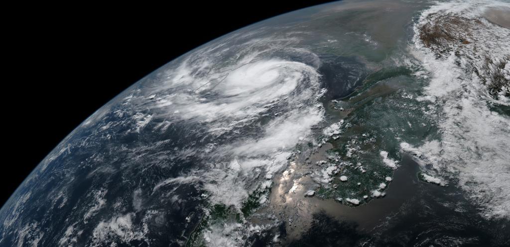
No country on Earth has been hurt by tropical cyclones as often, or as deeply, as Bangladesh. The reason is geography: a funnel-shaped bay, a shallow sea, and the largest river delta on the planet, much of it barely a few metres above the tide, crowded with some of the densest rural populations in the world. A review in the Bulletin of the World Health Organization counted about 718,000 cyclone deaths in Bangladesh over fifty years. Yet the same country's recent history holds one of the great public safety achievements of the modern age: storms as strong as those that once killed hundreds of thousands now kill dozens, because Bangladesh learned, at terrible cost, how to warn, evacuate and shelter its coastal people. This is the story of both halves of that record.
Cyclones in Bangladesh at a Glance
- The coast: about 710 kilometres of delta shoreline on the northern Bay of Bengal, home to tens of millions of people
- The seasons: two cyclone windows each year, April to May and October to November, around the monsoon
- The deadliest storms: Backerganj 1876 (about 200,000 deaths), Bhola 1970 (300,000 to 500,000), the Chittagong cyclone of 1991 (about 138,000)
- The turn: Cyclone Sidr in 2007, a storm of comparable strength, killed about 3,400; Cyclone Amphan in 2020 killed 26 in Bangladesh after 2.4 million people were evacuated
- The system: the Cyclone Preparedness Programme (CPP), founded 1972, now fields about 76,000 trained volunteers, half of them women, backed by thousands of cyclone shelters and a national warning chain
Why the Bay of Bengal Is So Deadly
A cyclone's killing weapon is rarely its wind. It is the storm surge: the dome of seawater the storm pushes before it onto the land. The northern Bay of Bengal is shaped to make surges monstrous. The bay narrows toward the Bangladesh coast like a funnel, the seabed shelves very gradually, and the tides of the Meghna estuary are among the largest in the world. A surge driven into that funnel has nowhere to spread, so it rises. In 1876 the water climbed as high as 13.6 metres in places; in 1970 it topped 10 metres over islands that themselves stand only a few metres above the sea.
Onto this geography, history placed people in extraordinary density. The delta's fertile, flood-fed soil supports village after village on land that a surge can erase in an hour, and for most of the region's history there was no warning, no shelter and no high ground: in 1876, survivors lived because they climbed the palm and coconut trees planted around their homes. Every element of the modern Bangladeshi system answers one item on that list of absences.
The Great Backerganj Cyclone of 1876
On the night of 31 October 1876, a severe cyclone drove straight into the Meghna estuary, in the Backerganj district of Bengal, today's Barisal region. Three great storm waves swept over some 3,000 square miles of coast and islands, submerging the islands of Dakhin Shahbazpur, Hatiya and Sandwip and the mainland shore within the hour, and surprising a million people in their beds. About half of the roughly 200,000 dead drowned that night. The rest died in the weeks after, of the cholera and famine that followed the salting of fields and wells, in one of the worst recorded epidemics in Bengal's history.
The 1876 cyclone set the pattern that would repeat for a century: an unwarned population, a surge out of the dark, and an aftermath of disease and hunger that killed as many as the water. It also entered the record books as one of the deadliest natural disasters of the 19th century anywhere in the world, a warning of what the bay could do that the following century would underline twice more.
Bhola, 1970: The Deadliest Cyclone on Record
The Bhola cyclone formed over the central Bay of Bengal in early November 1970 and came ashore on the night of 12 November, at the height of a spring tide, with sustained winds reported around 185 kilometres per hour and a surge that rose more than ten metres over the low islands of the Meghna estuary. The islands and chars of today's Bhola, Patuakhali, Barguna and Noakhali districts took the full force. Between 300,000 and 500,000 people died, the highest toll of any tropical cyclone ever recorded. More than 400,000 houses were destroyed, some 20,000 fishing boats were lost, and over a million cattle drowned.
There had been warnings of a kind, broadcast by radio, but no system existed to carry them to the islands, to make people believe them, or to give them anywhere to go. The catastrophe, and the distant and slow response of the government in West Pakistan, deepened the alienation of the Bengali population only months before the Liberation War, and historians count the cyclone among the events that shaped the birth of Bangladesh. The new state drew the practical lesson at once: never again unwarned.
1991: The Night Chittagong Was Hit
Twenty-one years later the system was tested again, and found still wanting. On the night of 29 April 1991 a cyclone of exceptional power, some 600 kilometres across with winds around 250 kilometres per hour, struck the coast near Chittagong with a surge of about six metres. It killed about 138,000 people, most of them in the coastal districts of Chittagong and Cox's Bazar, and caused damage estimated at more than 1.5 billion dollars. Warnings had improved since 1970, but many people did not hear them, did not believe them, feared for their property if they left, or had no shelter within reach.
Research after the 1991 storm produced one of the most consequential findings in disaster science: in surveyed communities, nearly 22 percent of the people who failed to reach a concrete or brick structure died, while every person who reached one survived. Mortality was highest among children under ten and women over forty. The conclusion was unavoidable: survival in a Bangladesh cyclone is decided less by the storm than by whether a strong building stands within walking distance, and whether someone trusted tells you, in time, to go to it.
The Turn: Volunteers, Shelters and Warnings
The machinery that now protects the coast was born from 1970. In 1972 the new government asked the Bangladesh Red Crescent Society to build a warning system, and the Cyclone Preparedness Programme began with just over 20,000 volunteers in seven coastal districts, equipped with transistor radios, megaphones, hand sirens and signal flags. Its task was the last mile: to take the meteorological department's forecast and carry it physically, door to door and village to village, and to help the elderly, children, pregnant women and people with disabilities reach safety.
The programme has grown into one of the largest community warning forces in the world: about 76,000 volunteers in some 3,801 village units, each unit of twenty volunteers split evenly between women and men, a design that matters in communities where male strangers cannot easily speak to women inside their homes. Behind the volunteers stand the shelters: thousands of purpose-built concrete cyclone shelters on raised plinths, most doubling as schools in normal times, supplemented by school buildings and, for livestock, raised earthen forts. Around them runs a national chain of forecasting and warning: the Bangladesh Meteorological Department's numbered signal system for the maritime ports, rising to Great Danger Signal No. 10 for the most severe storms, relayed by radio, television, mosque loudspeakers and, now, mobile phone alerts. The embankments and polders built along the coast since the 1960s hold back ordinary tides and moderate smaller surges, and the Sundarbans mangrove forest blunts the surge on the southwestern coast, a natural wall that storms such as Sidr spent part of their force crossing.
Reviews of the evidence, including the WHO Bulletin analysis, credit the combination, early warning, shelters, evacuation planning, embankments, coastal afforestation and public awareness, with the hundredfold fall in deaths, while noting honestly that the precise share of each element has never been isolated. The system was proven in action long before the reviews: during Cyclone Roanu in 2016, more than 55,000 CPP volunteers helped move over half a million people to safety before landfall.
Sidr, Amphan and Remal: The New Pattern
Cyclone Sidr, which struck the southwestern coast on 15 November 2007 with peak winds of about 260 kilometres per hour, was the strongest test of the new system in a generation. About 1.5 million people took refuge in shelters, and the official death toll was 3,406, a catastrophe for the families involved, yet a small fraction of what a storm of that power would once have taken. Sidr's deepest damage was economic: housing, agriculture and the embankments themselves, whose breaching during Sidr and again during Aila in 2009 left farmland salted and villages waterlogged for years.
The pattern held through the following decade. When the super cyclone Amphan approached in May 2020, in the middle of a pandemic, Bangladesh prepared more than 12,000 shelters and evacuated over 2.4 million people; 26 died. When Cyclone Remal crossed the coast near Khepupara on 26 May 2024 under Great Danger Signal No. 10, 9,424 shelters were opened and more than 800,000 people evacuated; the government's first confirmed count was 10 deaths, with 3.8 million people affected by surge, rain and power cuts across 19 districts. The storms have not weakened. The dying has been engineered down.
What Remains Unfinished
The unfinished business is now mostly about livelihoods rather than lives, and it is substantial. Embankments built in the 1960s are ageing, and a breached polder can salt a farming community's land for years, as Aila showed. Shelters, though far more numerous than in 1991, are still unevenly distributed, and women continue to report concerns about privacy, lighting and safety inside them, concerns the even gender split of the CPP only partly answers. Forecasts have improved enormously, but the final evacuation decision still rests on families weighing a warning against the risk of losing livestock, boats and homes to theft or water.
Above all, the climate is shifting the baseline. A warming Bay of Bengal is expected to produce a higher share of very intense cyclones, and sea level rise lifts the platform from which every surge starts, while the delta itself subsides. Bangladesh's achievement, cutting cyclone deaths a hundredfold in fifty years, is studied around the world as proof that a poor, exposed country can defend its people. Holding that achievement against a stronger sea is the work of the next fifty.
Sources
Haque et al., "Reduced death rates from cyclones in Bangladesh" (Bulletin of the World Health Organization) and its mortality series; Cyclone Preparedness Programme and Bangladesh Red Crescent Society programme histories; IFRC reporting on Cyclone Amphan (2020); Ministry of Disaster Management and Relief briefings on Cyclone Remal (May 2024); contemporary records of the 1876 Backerganj cyclone and the 1970 Bhola cyclone.